The technology, provided by Ecopia AI, is financed in part by Ontario’s Autonomous Vehicle Innovation Network (AVIN) and could improve the movement and safety of Toronto’s autonomous vehicles

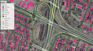
HD vector map imagery for autonomous vehicle applications (representative only). Source: Ecopia AI
The technology, provided by Ecopia AI, is financed in part by Ontario’s Autonomous Vehicle Innovation Network (AVIN) and could improve the movement and safety of Toronto’s autonomous vehicles
Canada’s largest city is an important step closer to realizing its goal — set out in its 2019 Automated Vehicles Tactical Plan — of being “AV ready.”
Yesterday, Ecopia AI, a local leader in digital mapping, announced it has partnered with the city and the province of Ontario to develop a high-definition 3D map of the city that will be available for the city’s use and for licensing by autonomous vehicle technology developers.

“The AV ecosystem demands a comprehensive, accurate and up-to-date fundamental dataset of vector maps that [provide] a detailed digital representation of the physical world,” says Jon Lipinski, Ecopia AI’s president and cofounder, in an e-mail interview with Electric Autonomy Canada.
Such maps must be custom-created as typical open-source maps or publicly available navigation maps aren’t suitable for AV testing and deployment.
In this case, says Lipinski, “detailed land cover features including road networks, pedestrian networks and other features such as 3D buildings are required to assist Toronto’s AV tactical plan.”
Funding from AVIN
Ecopia received $994,706 from Ontario’s Autonomous Vehicle Innovation Network (AVIN) R&D Partnership Fund to launch the project. Those funds are matched by Ecopia’s own $2-million investment in this initiative.
The goal of the R&D Partnership Fund, according to Raed Kadri, head of AVIN, is to support homegrown Ontario companies to commercialize leading-edge solutions that will scale into the global market. Ecopia’s application to the program was successful because it epitomizes this potential.

“It’s great to see an Ontario company commercializing a solution that people need,” says Kadri, in an interview with Electric Autonomy Canada. “When people talk about autonomous vehicles, they talk about 3D mapping. It’s part of the baseline of data that supports the AI in autonomous vehicle operations. Now we can say, ‘Here you go, Ontario’s got a company that’s providing a leading-edge solution. And how do we know it works? They’re commercializing it with the biggest city in our province and in our country.’”
Tactical plan proceeding
From Toronto’s perspective, having this map is integral in the development of its AV tactical plan, which aimed to have the city “AV ready” in 2022. That plan was introduced and approved by city council in 2019, at the time a North American first, though delays due to the pandemic may push the completion date beyond 2022.
Other steps in that plan now underway include the launch of transportation innovation test zones within the city and the rollout of an automated shuttle trial.
“Ecopia’s mapping will help Toronto become ‘AV Ready’ and supports the triple-redundancy data standard set in the Automated Vehicles Tactical Plan,” says Ryan Lanyon, manager, strategic policy and innovation in the city’s transportation services department and chair of the interdivisional working group on automated vehicles.
“This could improve the movement of AVs and contribute to increased safety for all of Toronto’s road users.”
Growth in AV mapping
Ecopia is not only an apt candidate for this project but an intriguing story in its own right. The company was founded in 2014-15, building on PhD research done by several of the founders at the University of Waterloo. It specializes in using its own proprietary AI systems to extract data from the latest satellite imagery to generate HD vector maps with “GIS-professional level accuracy.”
Early on it struck some important deals, including a partnership with U.S.-based DigitalGlobe, a space imagery vendor now owned by Maxar Technologies. One of its first joint projects involved creating the first and only HD vector map of every building in the United States.
Ecopia’s maps are now used for commercial and government applications in over 100 countries. It sees mapping to support the expansion of autonomous transportation as a new area of potential growth.
Besides ensuring accuracy, Lipinski cites particular technological challenges involving “rapid changes in urban environments and the need for a scalable and time-efficient mapping systems. As the underlying imagery is refreshed, Ecopia AI’s systems can ensure rapid re-mapping and change detection.”
Ecopia plans to incorporate the Toronto data into a what it calls a “centralized hub” for map data. It will be available for license through the platform and a series of APIs (application programming interfaces).
Further details for the platform have yet to be announced. The mapping project itself has a two-year term, but some initial results are expected before the end of 2022.
• Full Ecopia AI release here.


